|
Deep-ocean
Assessment and Reporting of Tsunamis (DART): |
| |
Brief
Overview and Status Report by F. I. González, H.B. Milburn,
E.N. Bernard, J. Newman
As part of the U.S. National Tsunami
Hazard Mitigation Program, the DART Project is an effort by
the Pacific Marine Environmental Laboratory of the
National Oceanic and Atmospheric Administration to develop a capability for real-time
reporting of tsunami measurements in the deep ocean. The systems utilize bottom
pressure recorders (BPRs) capable of detecting and measuring tsunamis with amplitudes
as small as 1 cm in 6000 m of water. The data is transmitted by acoustic modem
to a surface buoy, which then relays the information to a ground station via
satellite telecommunications. This concept has proved itself through several
deep ocean deployments of prototype systems that provided extended periods of
excellent data return. Design improvements in the next generation of systems
will reduce the high data losses experienced during other periods. A planned
network of six buoys in the north Pacific and equatorial region focuses on the
hazard to U.S. coastal communities. Once this technology matures, consideration
should be given to a coordinated international effort to establish additional
stations of direct benefit to other Pacific Rim countries. See
full article.
Animation of how the DART-system is working |
 Source:
NOAA/PMEL, Sketch of the DART System
Source:
NOAA/PMEL, Sketch of the DART System |
|
| |
|
|
Dart
Buoys provide real-time reporting of tsunamis |
| |
Summarised
by L. Kong (ITIC) from the International Tsunami Symposium 2001
proceedings: http://www.prh.noaa.gov/itic/tsunami_events/media/factsheets/tsunami_detection_buoy_article.pdf |
| |
|
|
Global
Sea Level Observing System (GLOSS) |
| |
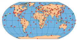
GLOSS is an international programme conducted under the auspices
of the Joint Technical Commission for Oceanography and Marine
Meteorology of the World Meteorological Organisation and
the Intergovernmental Oceanographic Commission. The programme
aims to establish a high quality global and regional sea
level network for application to climate, oceanographic and
coastal sea level research. The main component of GLOSS is
the 'Global Core Network' of 290 sea level stations around
the world for long-term climate change and oceanographic
sea level monitoring.
|
|
|
| |
|
|
Global
Seismographic Network (GSN) |
| |
GSN
is one of the four major components of the Incorporated Research
Institutions for Seismology (IRIS) Consortium, which is dedicated
to exploring the Earth's interior through the collection
and distribution of seismographic data. The goal of the GSN
is to deploy over 128 permanent seismic recording stations
uniformly over the earth's surface. It provides funding to
two network operators: IRIS/ASL
and IRIS/IDA,
Network
Operations Center.
|
 |
|
| |
|
|
Center for
Tsunami Inundation Mapping Efforts (TIME)
|
| |
TIME was created
to assist the Pacific States in the development and maintenance
of maps which identify areas of potential tsunami flooding. It
is part of NOAA’s National Tsunami Hazard Mitigation Programme.
|
| |
|
|
GFZ project
or other technical descriptions |
| |
Concept of the Federal Republic of Germany for the Establishment
of a Tsunami Early-Warning System in the Disaster Region of the
Indian Ocean
|