


|
|
|
| Hazards | |
| Droughts | |
| Earthquakes | |
| Fire | |
| Floods | |
| Volcanoes | |
| Regions | |
![]()
![]()
» PICTURES «
Hazards: Floods
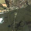 | Dessau, Germany, August 2002 This one-meter resolution satellite image was collected by Space Imaging's IKONOS satellite on Aug. 21, 2002. The image shows extensive flooding in eastern Germany where the Mulde River joins the Elbe River just north of Dessau, Germany. | 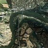 | Dessau, Germany, August 2002 This one-meter resolution satellite image was collected by Space Imaging's IKONOS satellite on Aug. 21, 2002. The image shows extensive flooding in eastern Germany where the Mulde River joins the Elbe River just north of Dessau, Germany. |
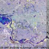 | Frankfurt (Oder), Germany 2001 This ERS SAR image covers an area of the River Oder around the town of Frankfurt. The left part is a multitemporal image using the images of the 5th August and 21st July. | 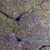 | Frankfurt (Oder), Germany 2001 This ERS SAR multitemporal image covers a large section of the River Oder around the town of Frankfurt, from Krosno (bottom right) to its confluence with the Warta. The magenta areas along the river are those flooded on the 5th August, while those in green-cyan where flooded only on the 6th August; the blue tones show areas flooded on both dates. |
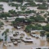
 | Mozambique, 2001 This community near Caia was slowly flooded by the rising Zambezi river. |  | China |
 | China | 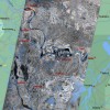 | Yangtze, China 1998 This ERS-2 SAR image, centerd around Huarong (200 km Southwest of Wuhan) and the Yangtze River, was acquired by the station of Ulan Bator (Mongolia) on the 1st of August 1998. |
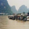
 | Piura, Peru |  | Piura, Peru |
| Page 1 | 2 | | |||