Compared to other natural hazards (tropical storms, floods,
droughts, etc.) destructive tsunamis occur relatively rare. But the recent
tsunami in the Indian Ocean dramatically showed what could happen if
a tsunami waves triggered by a major earthquake reaches coastal areas
without any early warning. The highly energetic tsunami waves struck
the costal areas devastating everything on their path. The costal population
lost everything, most of the poorly built houses could not stand the
massive flood or they were destroyed by flooding material. As floods
reached in some areas several kilometers inland wide districts are affected
by salinity. Crops, soil and wells for drinking water are contaminated
with salt water; it will take years until they could be used again.
What is a tsunami?
Tsunamis (Japanese for “harbour wave”) are a series of very
large waves with extremely long wavelength, in the deep ocean, the length
from crest to crest may be 100 km and more. Its height will be only a
few decimetres or less. That is why tsunamis can not be felt aboard ships
nor can they be seen from the air in the open ocean.
They are generated by any rapid, large-scale disturbance of the sea.
The waves could travel away from the triggering source with speeds
exceeding 800 km/h over very long distances. They could be extremely
dangerous
and damaging when they reach the coast because when the tsunami enters
shallower water of the coastal areas the velocity of its waves will
decrease and therefore the wave height increase. In shallow waters
a large tsunami
can crest to heights exceeding 30 m or the water level could rise in
a very short time for several tens of meters.
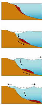
How tsunamis
are triggered
Most tsunamis, including the most destructive ones are generated by large and
shallow earthquakes which usually occur near geological plate boundaries, or
fault-lines, where geological plates collide. When the seafloor abruptly deforms
the sudden vertical displacements over large areas disturb the ocean's surface,
displace water, and generate destructive tsunami waves.
Animation of an earthquake
triggered tsunami
(http://ffden-2.phys.uaf.edu/645fall2003_web.dir/elena_suleimani/generation_small.mov)
The main factor determining the initial size of a tsunami is the amount of vertical
sea floor deformation which, in turn, is controlled by the earthquake's magnitude,
depth, and fault characteristics. Parameters which influence the size of a tsunami
along the coast are the shoreline and bathymetric configuration, the velocity
of the sea floor deformation, the water depth near the earthquake source, and,
the efficiency with which energy is transferred from the earth's crust to the
water column. Usually, it takes an earthquake with a Richter magnitude exceeding
7.5 to produce a destructive tsunami.
Volcanic eruptions, landslides or asteroid impacts could also trigger a tsunami
but much less frequently. Even so, one of the largest and most destructive tsunamis
was generated in August 26, 1883 after the Krakatoa (Indonesia) eruption. Major
earthquakes are suspected to cause underwater slides or slumps of sediment. It
is interesting to know that the largest tsunami wave ever observed was triggered
by a rock fall l in Alaska on July 9, 1958. A huge block (40 million cubic meter)
fall into the sea generating a huge wave but the tsunami energy diminished
rapidly away from the source and was hardly recognised by tide gauge stations.
|
|
Source:
Tsunami Community |
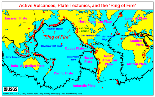
Where
tsunamis occur
Tsunamis can be generated in all parts of the world’s oceans and inland
seas. Because the majority of tsunamis are triggered by submarine earthquakes,
most occur in the Pacific Ocean. The Pacific Ocean is mainly bounded by subducting
geological plates which is also called the “ring of fire”. Even
if not very frequent, destructive tsunamis have been also been generated in
the
Atlantic Ocean (Portugal 1883) and the Indian Ocean (Sumatra 2004).
For further information see also the global
seismic hazard map.
|
|
Source: USGS |
How tsunami waves travel across the ocean
Once a disruption of the ocean floor has generated a tsunami the waves will
travel outward from the source – similar to the ripples caused by
throwing a rock into a pond. The wavelength and the period of the tsunami
waves depend on the generating source. A high magnitude earthquake of a
long fault line will cause greater initial wavelength (~ hundred km) and
period (from 5 to 90 minutes), similar to what a huge landslide could generate.
The deeper the water, the faster the tsunami wave will travel. In deep
oceans, waves can travel with a high speed of up to 800 km/h and lose
very little energy while travelling. The great tsunami waves in 1960 in
Chile reached Japan which is 16800 km away in less than 24 hours. In many
cases, despite tsunami waves travelling very fast, people living in high-risk
coastal areas can be warned if there are adequate communication structures
established and the people are aware of the risks they face.
How tsunamis behave as they approach land
The speed of the tsunami is related to the depth of the water. As the
water depth decreases, the speed of the tsunami declines. The transformation
of total energy of the tsunami leads to the growth of the tsunami
waves. Tsunami waves will, however, normally not reach the coast
as a huge wall of water. It may appear as a rapidly rising or falling
tide, a series of breaking waves, or even a bore. Reefs, bays, entrances
to rivers, undersea features and the gradient of the slope of the
beach all help to modify the tsunami as it approaches the shore.
The rise of the water level on shore varies in extreme cases; the
water level can rise to more than 15 metres for tsunamis of distant
origin and over 30 metres for a tsunami generated near the earthquake's
epicentre. Tsunamis may reach a maximum vertical height, called a
run-up height, onshore above sea level of 30 meters. Tsunamis consist
of a series of waves, the first of which may not be the largest.
Tsunamis have great erosional potential. The flooding of an area
can extend inland by many hundreds of metres, covering large expanses
of land with water and debris. Flooding tsunami waves tend to carry
loose objects as well as people out to sea when they retreat.
What is a Tsunami Early Warning System?
Early warning is much more than just a prediction. PPEW defines a complete
and effective early warning system as a package of four
elements,
spanning knowledge of the risks faced through to preparedness to
act on early
warning.
Strong linkages between the four elements are essential. Therefore
the major players concerned with the different elements need to meet
regularly to ensure they understand all of the other components and
what other
parties need from them, and to agree on specific responsibilities
throughout all four elements.
Key activities of
all types of early warning systems include:
(i) construction of risk scenarios, (ii) improvements to the early warning
system itself by adjusting it according to data and analysis from studies
of past events (iii) development and publishing of manuals, (iv) dissemination
of information, (v) practicing and testing of operational procedures
such as evacuations. All these activities need to have a solid base
of political support, institutional responsibility, availability of
trained people as well as necessary laws and regulations. Early warning
systems are most effective when established and supported as a matter
of policy
and when preparedness to respond is engrained in society.
The same basic factors are also valid for tsunami early warning systems.
When designing an effective early warning system, the following four
elements have to be considered because failure in any one part can
mean failure
of
the
whole
system.
|
Prior knowledge of the risks
faced by communities
Risks arise from both the hazards and the vulnerabilities that
are present; therefore, we need to ask what the patterns and trends
in these factors are. Several activities have to be undertaken
to gather knowledge of the communities and localities at risk.
- Hazard
assessment:
- Risk,
exposure and vulnerability maps
- Vulnerability
and hazard databases
- Source
location
- Tsunami
scenario databases
- Simulation,
modelling
- Periodically
reevaluate community vulnerability and exposure
- Land
use planning and strategies (no further development, redevelopment,
open space uses such as parks and agriculture, keep development
at a minimum level in hazard-prone areas)
- Construction
work such as reinforcement of buildings, dams, walls, drainage,
channels).
- Slowing techniques involves creating friction that reduces
the destructive power of waves. (Forests, ditches,
slopes)
- Steering techniques guide the force of tsunamis away from vulnerable
structures and people by using angled walls and ditches
- Blocking walls include compacted terraces and berms.
|
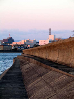 Tsunami protection wall, Japan.
 |
- Special
concentration on critical facilities (fire stations, power
substations, hospitals, sewage treatment plants) is needed.
These key facilities should not be located in inundation zones.
Relocation of these types of facilities out of inundation areas
is necessary, however, if the location within the hazardous
area is unavoidable than the buildings have to be designed
or retrofitted to survive tsunami damage.
- Special
building codes for buildings constructed in exposed/hazardous
areas – ensure that these codes and standards address
the full range of potential hazards (multi hazard approach).
- Evacuation
plan:
- Evacuation
lines and planes have to be in place
- Vertical
and horizontal evacuation have to be considered
- Incorporation
of hazard information into planning processes
- Adoption
of comprehensive risk management policies
|
|
Technical
monitoring and warning service for these risks
It is essential to determine whether the right factors are being monitored
and if accurate warnings could be, in fact, generated in a timely fashion.
- Around the clock operational capability and well trained
rapid response unites
- Hazard
and location assessment studies
- Exchange
of experiences when establishing a new early warning system
- Highly
reliable measurements
- Technical
equipment appropriate to local circumstances and well maintained
- Trained
staff to handle the instruments in a proper way
- Maintenance
of measurement instruments and facilities
- Continuing
education for the staff to keep up-to-date
- Coordination
and cooperation among relevant monitoring centres
- Cooperation
and communication channels/lines with the global seismic
network
- Cooperation
and communication channels/lines with tide gauge stations
network
Dissemination
of understandable warnings to those at risk
A critical issue regarding early warning systems is that the warnings
reach those at risk and that the people at risk understand them. The warnings
need to deliver proper information in order to enable proper responses. An additional
requirement for an effective evacuation/warning system is continuous public education.
Without education a system cannot be totally effective no matter how expensive
or sophisticated it is. To design an effective and efficient system, all groups
that take part in the notification process (emergency managers, media, etc) should
be involved in the planning and implementation of the system. This is to ensure
that all aspects of the systems are considered.
|
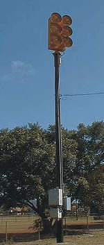 Tsunami siren, Hawaii
 |
- The
dissemination system has to be adjusted to incorporate factors
such as the size of the area at risk (compact/spread out),
its location (harbour/beach), people at risk (retirees/transit
population/tourists), financial resources of the community
and existing notification systems.
- Communities
at risk need to be equipped with the necessary instruments
to receive and further disseminate the warnings. Some of these
are:
- Sirens: good
coverage including isolated areas, controllable from
a central point for rapid notification, low maintenance
but high cost, vulnerable to sand and salt. The siren’s
meaning may not be recognized or ignored.
- Telephones: good
coverage, audio component (better understanding of the
purpose of the warning), tailored messaging but proximity
to the instrument necessary, expensive if rarely used,
cell phones beyond coverage area (??), direct dial only
(motels, offices excluded) problems in serving large
population.
- Radio: easy
to use, widespread, mobile, inexpensive, audio component,
rapidly transmitted message, but coverage limited to
those with radios, not all coastal areas are covered,
high rate of false alarms, radio must be on at all times.
- Emergency
Alert System (EAS): (Example from the US) wide
coverage, can broadcast evacuation notice, inexpensive,
consistent and ability to rapidly send message, but
radio/television must be switched on, not all radio/TV
stations are staffed 24 hours, does not work on satellite
TV, power dependent (some area no coverage)
- Pagers: inexpensive
if used for specific audience but coverage limited
- Billboards: simple,
always available, multicultural but often a victim of
vandalism
- Aircraft: reaches
remote areas, reach accessible areas which are not covered
by other means, complements other systems but limited
in number and coverage, slow response.
- Dissemination
systems in place for local and distant tsunamis.
|
Knowledge
and preparedness to act
Communities have to understand their risks, they need to respect the
warning service, and they have to know how to react if a warning is
issued.
- Implement effective
information and education programmesMaintain
the programmes over a long term
- Awareness
building/ training within the communities
- Curriculum for schools located in districts at risk
- Training and regular drill of emergency situation
- Plan for evacuation: horizontal evacuation (moving people to more distant
locations or higher ground) vertical evacuation (moving people to higher
floors in buildings)
- Inventory of buildings (potential for vertical evacuation)
- Identify specific buildings to serve as vertical shelters
- Agreements with house owners
- Maintain communities interest in natural hazards, annual events (tsunami
week, integration into social life)
For further reading please see:
Designing for Tsunamis: Seven Principles
for Planning and Designing for Tsunami Hazards, Richard Eisner and others,
2001. US National Tsunami Hazard Mitigation Program. http://www.prh.noaa.gov/itic/library/pubs/online_docs/Designing_for_Tsunamis.pdf
Tsunami Warning Systems and Procedures: Guidance for Local Officials
Oregon Emergency Management and Oregon Department of Geology and Mineral
Industries, 2001. http://www.prh.noaa.gov/itic/library/pubs/online_docs/SP%2035%20Tsunami%20warning.pdf
|