| The
Secretary-General- Message on the International Day for Disaster Reduction |
|
| Information Kit | |
| Volcano Daily | |
| Press release | |
| Announcement | |
| Sticker | |
| Poster | |
| "Disaster Reduction for Sustainable Mountain Development" | ||
| 2002 United Nations World Disaster Reduction Campaign | ||
| Information Kit | ||
|
Dear Readers, In order to explain and promote disaster reduction to an increasing cross-sectoral audience worldwide, the United Nations Inter-Agency Secretariat of the ISDR organises public awareness campaigns - entitled World Disaster Reduction Campaigns- on a new theme every year. It gives me great pleasure to introduce you to this booklet on “Disaster Reduction for Sustainable Mountain Development” which is this year’s chosen theme. The theme was selected for two reasons; first, because mountain communities are particularly vulnerable to natural disasters and we hope that they will benefit from the information and experiences mentioned in this booklet. Second, our theme was selected in parallel to the celebration of the International Year of Mountains by the United Nations this year, under the leadership of the UN’s Food and Agricultural Organization (www.mountains2002.org), whose aim is to promote sustainable mountain development worldwide. The lead article of this booklet was written by our colleagues from the International Centre for Integrated Mountain Development (ICIMOD-www.icimod.org) based in Nepal. I wish to warmly thank ICIMOD and all the other contributors to the booklet for their valuable time and material. Many UN entities, governments, regional and national organisations, NGOs, research institutions and private individuals are involved in disaster reduction projects for sustainable mountain development. Please get in touch with the ISDR Secretariat for useful contacts in your area or check page 15. The World Disaster Reduction Campaigns are given special emphasis every year on the second Wednesday of October with the celebration of the International Day for Disaster Reduction. You will find suggestions for the celebration of the Day on page 14 of the booklet and on our website at www.unisdr.org. Further support material related to “Disaster Reduction for Sustainable Mountain Development”, includes a poster and a booklet on volcanoes for children, all of which can be obtained from the ISDR Secretariat. The ISDR Secretariat is currently working on a global review of
disaster reduction initiatives. I wish you a pleasant and informative read. Definitions of key concepts issues can be found on page 4. Sálvano Briceño |
| Contents | ||||||||||||||||||||||||||||||||||||||||||||||||||||||||
|
The
International Strategy for Disaster Reduction (ISDR) The implementation of the Strategy is premised on the establishment of partnerships between governments, civil society organizations, UN agencies, the scientific community, the media as well as other relevant stakeholders in the disaster reduction community. The four goals of the Strategy are to increase public awareness about disaster reduction, to obtain commitment from public authorities, to stimulate inter-disciplinary and inter-sectoral partnerships, and to improve the scientific knowledge of the causes of natural disasters and the consequences of the impact of natural hazards. The UN General Assembly has mandated two additional tasks which are directly relevant to disaster reduction; the continuance of international cooperation to reduce the impacts of El Niño and La Niña and the strengthening of Early Warning Systems. |
||||||||||||||||||||||||||||||||||||||||||||||||||||||||
| The
Inter-Agency Secretariat of the ISDR Within the United Nations system, the Secretariat of the International Strategy for Disaster Reduction is responsible for coordinating disaster reduction strategies and programmes and serves as facilitator among partners. Its mission is to help people withstand disasters by making them aware of the importance of disaster reduction measures and providing support to help reduce human, economic and social losses. The Secretariat also provides backing to the Inter-Agency Task Force on Disaster Reduction headed by the Under-Secretary-General for Humanitarian Affairs and comprising representatives of several United Nations agencies, regional institutions and non-governmental organizations. Within the United Nations system, the Inter-Agency Task Force on Disaster Reduction is the main body responsible for the design of disaster reduction policy. |
||||||||||||||||||||||||||||||||||||||||||||||||||||||||
|
What
is a “Natural” Disaster? What is Disaster
(Risk) Reduction? What is a Natural
Hazard? What is Sustainable
Development? The International
Year of Mountains and Sustainable Development |
||||||||||||||||||||||||||||||||||||||||||||||||||||||||
|
To date, mountain complexity has made it impossible to provide a thorough definition of mountains with universal application. The following is a list of elements that help describe mountains: Elevation zones: Cartographic compilation showed that 48 percent of the world's total terrestrial surface lies above 500 m; 27 percent above 1 000 m; 11 percent above 2 000 m; 5 percent above 3 000 m; and 2 percent above 4 000 m. These statistics provide an approximation for describing mountain areas. Morphology and climate: "Steep slopes" (characterized by geomorphologically high-energy environments with frequent mass transfers down slope) and "altitude" (characterized by low temperatures and, in certain cases, aridity) are aspects of mountain or highland landscapes which individually, or as a system, lead to marginality for human utilization and adaptation. Latitude: The climatic effects of higher latitudes through the poles mean significant areas in these regions have mountainous characteristics despite only moderate altitudes. Biodiversity and food security: Mountains contain high biological diversity, often of global relevance. Consequently, mountains are also important centres of crop diversity, a key factor in agriculture worldwide and water resources. Land-use opportunities and constraints: From the humid sub-tropical and temperate zones pole wards, all land-use activities in mountain areas are disadvantaged compared with the subjacent, neighbouring, and more densely populated flatlands. But from the subtropical arid zones to the tropical humid zones, some higher altitudinal belts are more beneficial for human land use than lower altitudes because of better moisture and temperature conditions. Conflicts and cooperation: Mountains often constitute geo-political borders and can be sites of potential/current tensions or even conflicts owing to their rich natural resources and strategic relevance. Within countries too, mountain areas can be places of tension and conflict. Highland-lowland interactions: Highlands and lowlands are interconnected through often very complex linkages; therefore the interest in mountain areas should not stop at the contour lines. Looking beyond mountain areas into the ecological, economic, social and political dimensions of highland-lowland interactions is an issue of growing importance. This is particularly relevant in the context of lowland vulnerability to mountain hazards.
|
||||||||||||||||||||||||||||||||||||||||||||||||||||||||
Disaster
Reduction for Sustainable Mountain Development Mountain Hazards
and Disasters The hazards are inherent in the mountain terrain: extreme slopes and unstable formations turn heavy rain or snow into agents of destruction. Water loosens boulders, soaked earth slips down exposed rock faces, melting snow breaks away and crashes down, and the roads and trails clinging to hillside slopes and creeping precariously through narrow valleys are blocked or broken away, or rivers in valley bottoms are temporarily dammed only to release their waters some time later in a disastrous flood wave. Mountains by
their nature are growing and changing areas: rain induces soil
erosion, freezing, thawing and circulation of water break down
rock. In some areas, like the Hindu Kush-Himalayas, the mountains
are themselves still being formed as a result of movements in
the earth’s crust, earthquakes and tremors. In other parts
volcanic activity adds to the hazards. More recently, land degradation
and loss of ground cover are suspected of contributing to an
increased incidence of disasters, compounded by changing climate
patterns that may reduce predictability and negate tried practices
of hazard reduction. The environmental and economic costs of
mountain disasters are immense. Even more than these costs are
the loss of lives and the impact of progress in mountain communities
who work, like the rest of us, towards better futures for their
children. Natural Disasters
and Sustainable Development The Solutions-Disaster
Reduction Measures in Mountains |
||||||||||||||||||||||||||||||||||||||||||||||||||||||||
What can
be done? But all these approaches to disaster reduction face difficulties in mountain areas. The detailed information needed is generally lacking, and difficult to collect; communication systems are often poor, slow or inappropriate; and resources are not only limited in these often poor areas, they are stretched by the scattered habitation, huge distances, and problems of accessibility. There are often big constraints in the land area available, sometimes there is no other possibility than to build a house or road in a position known to be at risk. However, much is being done. Science is being used to elucidate processes through geophysics, geomorphology, geology, rock mechanics, soil science, hydrology, seismology, and climatology to provide a basis for predicting hazards and risks; technology is coming up with the techniques that facilitate the means to hold back disaster. Across the world, technicians and engineers are working to reduce the impact of mountain disasters with activities ranging from fencing to prevent avalanches in the Alps, to integrated control measures to prevent debris flows in the HKH for example. Between 1991 and 1994 an integrated system of civil engineering and bioengineering measures costing only US$ 170,000 were successfully used to stop a recurring debris flow in the Laogan Ravine in China that had caused losses of almost US$ 5 million over a number of years and destroyed or threatened a railway, road, and canal. In 2000, a monitoring and early warning system and risk mitigation plan prevented many deaths in China when a landslide dam formed and breached sending a flash flood 50m high down the Yigong river, but cross-border communication failed and downstream in India more than 30 people died. Scientists have produced essential information on such diverse topics as hydrology and landslide mitigation in Switzerland (University of Bern), mountain risk engineering in India (University of Roorkie), landslide research in China (Beijing Institute of Geology), avalanches in Switzerland (Snow and Ice Research Laboratory in Davos, and debris flows and earthquakes in Japan. Satellites are being used to obtain information about events in otherwise inaccessible areas. Like everything else in mountain areas, disaster reduction is a field that attracts a handful of dedicated people. It is, however, a field so vast that today, during the UN’s International Year of Mountains, governments ought to ask themselves if the attention and inputs they provide are sufficient, particularly in view of the impact of mountain disaster on water and power supplies in so many areas of the world, and on the potential for development of mountain areas. By G.M. Pennington and A.B. Murray* References
|
||||||||||||||||||||||||||||||||||||||||||||||||||||||||
| Concrete examples of disaster reduction for sustainable mountain development | ||||||||||||||||||||||||||||||||||||||||||||||||||||||||
Education in disaster reduction The ICIMOD (www.icimod.org) began to focus on disaster reduction rather than disaster relief in 1988. It made use of the sponsorship and interest of the Commission of the European Communities (www.europa.eu.int, http://nedies.jrc.it) to embark on an ambitious mountain risk-engineering (MRE) programme which produced a nine-week course for engineers on the concept and techniques of building mountain infrastructure with a view to reducing the number of disasters likely to occur. The textbook of the course has since been used in universities and engineering colleges across the Hindu Kush-Himalayan Region (Deoja et al.1991). Since then, ICIMOD has been involved in training in disaster reduction and produced a further valuable resource book to support engineers and technicians in the field (Li Tianchi et al. 2001). The United Nations Environment Programme (www.unep.org), for example, has sponsored work on the mapping of potential sites for glacial lake outburst floods making use of remote sensing data, undertaken by ICIMOD and completed for Nepal and Bhutan (Mool et al.2001).The World Meteorological Organization (www.wmo.ch) has joined with ICIMOD to develop a regional flood forecasting system using satellites to facilitate the rapid exchange of data. |
||||||||||||||||||||||||||||||||||||||||||||||||||||||||
Cooperation in disaster reduction in Chamonix, France Disaster reduction is and should be multi-sectoral and interdisciplinary by nature. The more information to share in disaster planning, the better. Therefore, many people and institutions must be involved in a wide variety of interrelated activities at all levels. Following the 1970 avalanche in Val d’Isère (in the constituency of Chamonix Mont-Blanc, France), a special safety commission was created. The commission is composed of local government officials, local representatives of the meteorological department, of the railways, of the police, army and fire fighters, of local business people, and of mountain professionals such as ski instructors and guides. The commission produces recommendations which are forwarded to the Mayor and taken into account in the disaster management planning of this highly popular ski resort. For further information, please contact: Nadine Georgel, University of Grenoble, France, email: nageorgel@netcourrier.com |
||||||||||||||||||||||||||||||||||||||||||||||||||||||||
Disaster reduction in the Caucasus The United Nations Development Programme (www.undp.org) has been coordinating disaster reduction programmes in the Caucasus since 1997. The countries involved are Armenia, Azerbaijan and Georgia. The Caucasus has a history of natural disasters among which are earthquakes, mudslides and landslides. Given the countries’ political struggle and their degree of social and economic progress in the post-Cold War era, none of them can afford further setbacks in growth and development. The projects center around the development of early warning systems, disaster preparedness training and rapid response, as well as research in the psychological, legal and environmental aspects of disaster reduction managed by national focal points in each country. |
||||||||||||||||||||||||||||||||||||||||||||||||||||||||
The benefits of risk-mapping in disaster reduction - A case in Austria In many mountains areas, avalanche zoning has become quite common. In the case of Austria, risk planning became part of forestry law in 1975. A key feature is the identification of avalanche danger zones (among other mountain hazards). Colour codes define the different levels of danger. A red avalanche danger zone may thus not be used for building whereas yellow danger zones can be zoned for building and construction subject to certain conditions, such as the reinforcement of outer walls, set by the competent local authority. The limit for the red danger zone was set at the point where the pressure generated by an avalanche exceeded 2.5 tons per square metre. But because a lot of damage still occurred in the border zones between red and yellow, the Austrian Government set a new limit at 1 ton per square meter as the edge of the red zone. Although there are many more criteria to take into account in avalanche management, the tightening of the building zones in avalanche prone areas provides a good example of disaster reduction in practice.For more information, please contact: The International Commission for the Protection of the Alps, www.cipra.org |
||||||||||||||||||||||||||||||||||||||||||||||||||||||||
The case of Mount Usu in Japan The volcanic eruption of Mount Usu in Japan (March 2000) is an ideal showcase for sound disaster reduction for three reasons; first of all, the early warning system in place (which monitored the rapid increase in earthquake tremors) allowed for the timely warning of the communities residing close to the volcano. Second, the coordination between the national government, the local authorities and the private sector allowed for a very efficient information flow and smooth logistical evacuation procedures. Third, a pilot project instigated by the Asian Disaster Reduction Center and the National Space Development Agency of Japan allowed for the live observation of the disaster, as it was unfolding, via satellite. The voice and motion picture data was made accessible on the Internet. A disaster expert was thus able to give instructions for the efficient management of the event. Less disaster specialists needed to go onsite and the live satellite coverage allowed for a better overall observation of the situation.For more information, please contact the Asian Disaster Reduction Center: email: rep@adrc.or.jp or www.adrc.or.jp |
||||||||||||||||||||||||||||||||||||||||||||||||||||||||
Disaster reduction in history The Incas living in the Andes between the thirteenth and fifteenth century took great care to create terraces on steep slopes to conserve the scare soil and water necessary for their crops. Many of these terraces remain today, as do similar constructions maintained for over a thousand years in the mountain provinces of Indonesia and the Philippines. |
||||||||||||||||||||||||||||||||||||||||||||||||||||||||
Technical assistance for disaster reduction in India The 1999 earthquake (6.8 Richter Scale) in the Chamoli region of the Central Hymalayas, Uttaranchal, India, was the second earthquake of this magnitude in the region in a decade. It caused the damage of around 65000 houses. The event brought about the necessary political commitment to act so as to avoid similar occurrences in the future. A loan was approved by the Asian Development Bank for a Technical Assistance project to the state of Uttaranchal to be administered by the Asian Disaster Preparedness Center. A Disaster Mitigation and Management Center was created. Politicians were briefed by a concept paper and study tours, the technological communications’ infrastructure was reviewed and disaster resilient systems were designed. Reforms in the earthquake engineering curricula were developed and local community residents were given educational material and courses on disaster management planning. By the time the project is fully implemented, it will represent an effective disaster reduction module to be repeated in other earthquake prone areas.For more information, please contact: www.adpc.org |
||||||||||||||||||||||||||||||||||||||||||||||||||||||||
Disaster reduction Europe-wide The European Union (www.europa.eu.int) funds numerous disaster reduction projects Europe-wide. One of them, entitled “DAMOCLES”, contributes to advancing the technologies for the quantitative assessment of debris flow and rock fall hazard in order to disseminate these techniques to the end-users.For more information, please contact: www.europa.eu.int or www.nedies.jrc.it |
||||||||||||||||||||||||||||||||||||||||||||||||||||||||
The economics of disaster reduction in Latin America MERCOSUR, the economic union of the Southern Cape of the Americas comprises Argentina, Brazil, Bolivia, Chile, Paraguay and Uruguay. It was founded in 1995 and faces the need to find cost-effective ways to use Chile’s Pacific Ocean ports as a link to East Asia and the Western ports of the North American Free Trade Agreement (NAFTA). But the geomorphologic structure of South America challenges the above. The Andes offer very few East-West passages which increases the risks and the costs of trade. With the launch of MERCOSUR, the most accessible East-West passages became bottlenecks, very difficult to manage due to the increase in overland shipping (the Cristo Redentor-Los Libertadores pass, which links Chile to Argentina is a trade route servicing 200 million people) and the inability of the regional alliance to build the infrastructure and provide the maintenance needed to counter the challenges of dangerous mountain passes. The risks posed by natural hazards have therefore also increased significantly. The “Central Bi-Oceanic Corridor” is the passage way of around 70% of MERCOSUR trade. The Andean section of the Central Bi-Oceanic Corridor, called the Andean Corridor is the only mountain pass with the infrastructure and services needed to handle such a trade volume and is of strategic importance for the flow of goods and services between the Atlantic and the Pacific. Given that snow storms or landslides have blocked mountain passes for up to 10 days, and therefore cost the business sector very high losses, improving the infrastructure of the Andean corridor and adopting newer and more effective technologies have become the joint responsibility of the governments of Chile and Argentina. Both countries have launched action plans in capacity building, land use and preventive disaster management and are coordinating their actions through bilateral protocols with the overall aim to ensure the sustainability of the Corridor and its trade in the new international environment. Although the case of the Andean Corridor is not completed yet, it underlines the fact that the need for sound disaster reduction policies and actions can be at the heart of international cooperation initiatives. Further, once put in a strict economic context, disaster reduction can show its costs and benefits fast and obviously. For more information, please contact Ms Nelly Gray de Cerdán, Director, Centre of MERCOSUR Territorial Strategies of Cuyo University, Argentina, email: nelgray@spsarg.com |
||||||||||||||||||||||||||||||||||||||||||||||||||||||||
The case of Africa The African continent covers about 20 percent of the Earth’s land surface and houses nearly 500 millions people. About 10 percent of Africa’s surface area is made of highlands, mountains or steep sloping areas. About 50 percent of the countries in Africa contain mountains or have steep land problems. The number of people affected by mountain problems is about 20 percent of Africa’s population and a further 30 percent, or 150 million people, depend on water resources originating in mountain systems.Although mountains are generally perceived as areas where the conditions of human life are difficult, African mountains and highlands have been very attractive for human land use. As a consequence, the average population density in African mountains is more than double the density of the lowlands. Since more than 70 percent of the African workforce is engaged in agriculture, problems of degradation affect African people more seriously than people in other mountain systems of the world. Floods and drought are therefore the most common hazards in African mountains, resulting from changes in the water regime due to long-term soil erosion and soil degradation. Controlling population growth and the introduction to and management of environmentally sound farming techniques are key to reverse these trends. For information on disaster reduction projects in Africa, please contact Dr Ailsa Holloway, Disaster Mitigation for Sustainable Livelihoods Programme, University of Cape Town, South Africa Email: Holloway@enviro.uct.ac.za For more information on issues related to African mountains, please check: www.mountain-portal.co.uk |
||||||||||||||||||||||||||||||||||||||||||||||||||||||||
| A Word on Disaster Statistics:
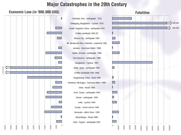
The general trend is: more and more disasters, less deaths, but more affected populations and increased economic losses. It is challenging to attempt a compilation of global statistics in the field of natural disasters. The insurance and re-insurance sectors are a popular source of data, and frequently used. But their figures need to be treated with caution, as they tend to be linked to insurance claims in developed countries and often do not represent the cost of the disaster in terms of percentage of a given country’s Gross National Product (GDP). The social and economic cost of disasters is difficult to estimate. Additionally, the remoteness of many communities in mountain areas means that disaster losses will often not be recorded at all. In some cases, disaster statistics are more precise on a smaller scale, at the national or regional level. However, this is not the case in all regions, notably in Africa where the lack of coherent data means that the impact of disasters is highly underestimated. Below is an example of the impact of major catastrophes in the 20th century.
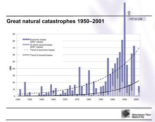
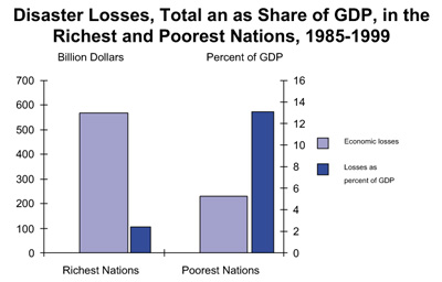
MunichRe looked at the trend of economic losses and insurance costs over a 50-year period linked to what it calls “great natural catastrophes”. There were 20 of these, costing the world US$ 38 billion (at 1998 values) between 1950 and 1959. However, between 1990 and 1999, there were 82 such major disasters and the economic losses had risen to a total of US$ 535 billion. That is, disasters had multiplied fourfold but economic losses were 14 times higher. And in each decade in between, both the number of great disasters and the economic loss involved had risen steadily. The global trend is that disaster impacts are on the rise, even if losses in 2000 and 2001 were down. These are absolute figures of economic loss, most of them to be found in developed and industrialised countries. But seen as losses by percentage of GDP, it is developing countries that loose most in relative terms, as shown in the graphic below (based on figures provided by MunichRe). For example, the economic losses of the United States from the 1997-98 El Niño event were estimated to US$ 1.96 billion or 0.03 per cent of GDP. The economic losses in Ecuador were 2.9 billion US$, but this represented 14.6 per cent of GDP (ECLAC 2000). Developing countries deserve the urgent attention of the international community. Twenty-four of the 49 Least Developed Countries (LDCs) still face high levels of disaster risk. At least six of them have been hit by between 2 and 8 major disasters per year in the last 15 years, with long-term consequences for human development (UNDP 2001).
|
||||||||||||||||||||||||||||||||||||||||||||||||||||||||
|
At the local level
At the national level
At the international level A number of events are organized as part of the International Year of Mountains
and as part of the World Summit on Sustainable Development. Information on
these events can be found on the IYM website (www.mountains2002.org), on the
ISDR
|
||||||||||||||||||||||||||||||||||||||||||||||||||||||||
|
For any requests on material or sources in this booklet, please contact the ISDR Secretariat. The contact list below, composed of the members of the Inter-Agency Task Force for Disaster Reduction, offers valuable further sources of information in the disaster reduction field.
|
||||||||||||||||||||||||||||||||||||||||||||||||||||||||
Some of the greatest mountain systems are listed below. The Alps The Andes The Atlas The Himalayas
|
||||||||||||||||||||||||||||||||||||||||||||||||||||||||