| Hayman Forest, USA, June 2002 | ||
| Details: | JPG, 768 x 960 Pixel, 96 dpi | |
| Copyright: | European Space Imaging (EUSI) http://www.Euspaceimaging.com | |
 |
|
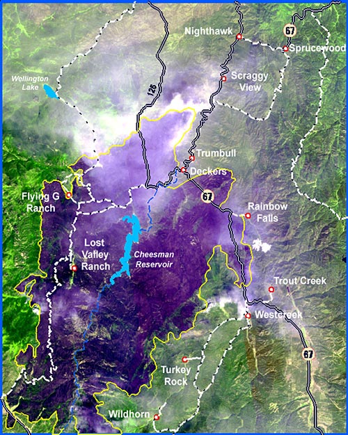
These reduced resolution satellite images to show an overview of the Hayman Forest Fire burning in the Pike National Forest 35 miles south of Denver. The images were collected on June 12 and June 20, 2002 by Space Imaging's IKONOS satellite. Each photo is comprised of several IKONOS images that have been reduced in resolution and combined (mosaiced several scenes together) to better visualize the extent of the fire's footprint.
In the natural color image (June 12), the gray-green area underneath the white smoke is burned vegetation and the darker green area is healthy vegetation. The enhanced color image (June 20) was taken with the satellite's near-infrared sensor. In the enhanced color image, the burned area is purple and the green areas are healthy vegetation. According to the U.S. Forest Service, when the June 12 image was taken, the fire had consumed 86,000 acres and has become Colorado's worst fire ever. The burned area on the June 12 image measures approximately 20 by 10.5 miles. This type of imagery is used to assess and measure damage to forest and other types of land cover. It also is used for fire modeling, disaster preparedness, insurance and risk management and disaster mitigation efforts to control erosion or flooding after the fire is out. One-meter high-resolution imagery from IKONOS can also be used to evaluate damage to individual structures. |