Winners of Risk Mapping Contest
As part of the United Nations 2001 World Disaster Reduction Campaign, a Risk Mapping Contest was launched as one of the various ISDR awareness and promotion activities keeping with the year’s theme ‘Countering Disasters, Targeting Vulnerability’.
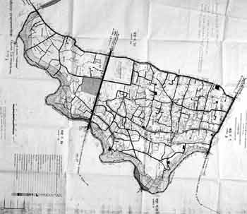
A risk map is a map of a community or geographical zone that identifies the places and the buildings – homes, schools, health facilities and others – that might be adversely affected in the event of hurricanes, earthquakes, tsunamis, floods, volcanic eruptions, landslides, and other natural hazards and related technological or environmental disasters. The production of a risk map requires consideration of areas and features at risk within the community or geographic zone, consultation with people and groups of varying expertise and the discussion of possible solutions to reduce risk.
Purpose and Scope
The purpose of the Risk Mapping Contest was to challenge people to produce
a risk map for their local geographical zone or community. The exercise
provided an opportunity for schoolchildren, teachers and local communities
to read, research and learn key concepts of disaster reduction, as
well as consider vulnerability and the potential threat of natural
hazards to their local surroundings. By increasing public awareness
about disaster reduction, more disaster reduction measures could be
developed and implemented in all sectors of society.
The Risk Mapping Contest encouraged participants to consult and interact with the various actors in natural disaster reduction such as public authorities, healthcare workers, non-governmental organizations and environmental experts. Communication and interaction between different people allowed for more effective collaborative efforts towards building a culture of prevention from natural disasters.
The Risk Mapping Contest was an integral part of the overall 2001 World Disaster Reduction Campaign, and made a valuable contribution in its capacity to reach its target audience, school children and local communities.
Implementation
The Risk Mapping Contest was publicised globally through the ISDR extensive
list of partner organisations and contacts, the UNDP Resident Representative
network and through the ISDR website www.unisdr.org. A flyer used to
promote the Contest and outlines the guidelines and rules (attached).
The Risk Mapping Contest offered a grant to the first and second best
submissions of the Risk Mapping Contest, to go towards their continuing
efforts in reducing risk and vulnerability in their communities. A jury
assembled by the ISDR Secretariat decided upon the winners on 15 April
2002, recommending each grant to be the equivalent of US $500 per submission.
Minutes of Risk Mapping Contest Jury Meeting
15 April 2002
Risk Mapping Contest Jury Members:
Mrs. Helena Molin-Valdes, Senior Officer, ISDR Secretariat, Geneva
Ms. Nicole Appel, Awareness and Promotion Officer, ISDR Secretariat,
Geneva
Mrs. Yasemin Aysan, Senior Officer, UNDP, Geneva
Mrs. Tanya de Corrales, PREANDINO/Andean Development Bank, Caracas
24 submissions were received for the Risk Mapping Contest from a total of 7 countries. All submissions for the Risk Mapping Contest received by the ISDR Secretariat were divided according to the category they represented (Local Communities or Children) and put on display. Jury members reviewed each submission according to the criteria for selection, with the first and second best submissions in each category awarded according to the points accumulated in the criteria for selection.
The criteria for selection were developed with a scale ranging from 3 (excellent) to 1 (poor) in the following categories:
- How closely the instructions of the risk mapping contest were followed
- The number of individuals or groups involved in the exercise (the more, the better as this promoted cross-sectoral partnerships)
- The clarity of the illustrations, taking different age groups into account
- The relevance and clarity of the attached written description, including the balance between descriptive and prescriptive elements
- The relevance of the usage of the map (was it disseminated for public awareness purposes in schools, church groups, youth clubs, professional associations etc.)
The winners of the risk mapping contest were:
| Local Communities Category | |
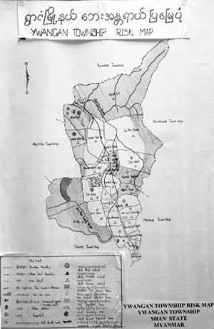 |
1st: Daw San YiU Tin Ko KoC/O Community Water Supply and Sanitation Project MYA/9/002No. 6 Natmauk Road, UNDPP.O. Box 650,YangonMyanmar |
 |
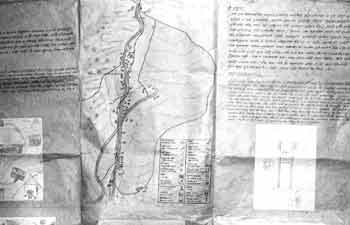
2nd:CTAR PiuraComité regional de defense CivilAv. San Ramón s/n Urb. San Eduardo El ChipePiuraPeru |
 |
|
| Children’s Category: | |
 |
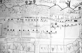
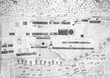
1st:Shree Bal
Bikash Secondary SchoolTaributte, Alapat V.D.C.Kathmandu DistrictNepal Tel: +977-1-450196 |
 |
2nd:Instituto Nacional de Berlin1er Año de Bachillerato Tecnico Vocacional, Seccion “C”, Mayo de 2001DPTO, UsulutanEl Salvador |